|
Log Book
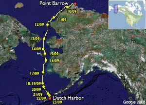
Leg 8 :
Point Barrow - Dutch Harbor (Alaska)
(10 - 23 September, 2008 |
|
|
Leg 8
Point Barrow - Dutch Harbor (Alaska)
(10 - 23 September, 2008 )
|
|
23 september , 2008 (Onboard
time = UTC - 8)
Dutch Harbor, Spit Dock,
53°54’N – 166°30’W
22h00 local time
We set sail early because we want to be in Dutch Harbor before the wind starts to blow hardly. When we arrive, we remark that the tiller is hard to
manoeuvre and find out that a part is broken. Fortunately it happens just when we arrive and we’re in the good spot to fix it with a lots of workshops.
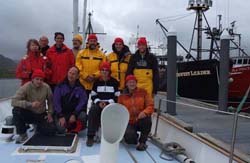
Our arrival to Dutch Harbor marks the end of our leg number height. We’re now away from the Arctic region. In the South starts the immensity of the Pacific
Ocean.
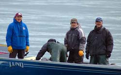
For this leg the crew was :
On top from left to right : Monique Golliot (France),
Emmanuel Correia (France),
Guy Clavel (France),
Bernard Grunewald (France),
Milos Gregar (Tchéquia),
Honza Gregar (Tchéquia),
Lukas Reitinger (Tchéquia).
On bottom from left to right :
Laurent Ceresoli (France),
Michel Mottier (Swisserland),
Eva Skorepova (Tchéquia),
Olivier Pitras (France).
|
|
22 september , 2008 (Onboard
time = UTC - 8)
Unalaska, Kalekta Bay,
53°57’N – 166°22’W
22h00 local time
We sail in the darkness on a flat sea. The wind is decreasing while we’re approaching the coast. Couple of fishing boats confirm that we’re in the vicinity
of Dutch Harbor. Soon, the first lights of the city are visible on starboard side but we keep going on the route toward Kalekta Bay further East, near
Akutan Pass.
Couple of hours before sunrise the moon rises up behind the clouds and give enough light to distinguish the black steep slopes of the
mountains. In the night they look gigantic. We enter the bay which is visible only with the radar. Eyes do not see any perspective, the darkness is total.
Only summits and ridges are visible and drawn the upper part of a deep black wall who rises up more and more, too much for our senses. A quick look to the
radar tells us we’re still at 300 meters from the coast, we cast anchor, it’s 5h15 AM.
When we wake up, the boat is flooded by the sun. Slopes, deeply eroded, green, are a symphony for the eyes. We go on shore as soon as possible to enjoy this
beautiful day. This small summit at 600 meters is OK to start. We did not walk really since Greenland. From the top, the view is amazing. Only volcanoes can
shape such chaotic and gorgeous landscapes. We thank again this high pressure squeezed between two storms who gave us the opportunity to live such an
exceptional day in this period of equinox. South winds are expected tomorrow. |
|
21 september , 2008 (Onboard
time = UTC - 8)
Bering Sea, Approach of Unalaska
This high pressure who resists in the South of the Aleutian is
providential. We can enjoy a steady wind from West to South West and we
should keep it till destination before the Southerly wind predicted in
48 hours. A storm is building up south of Kamchatka, we have to keep a
sharp eye on it. What ever, we’re sailing comfortable, what a change
comparing with the rolling business of yesterday. We should arrive
tomorrow morning at the anchorage we choose for landing on Unalaska
Island. The night arrives, we’re 40 milles away from the bay.
|
|
20 september , 2008 (Onboard
time = UTC - 8)
St Paul, Pribilov
22h50 local time
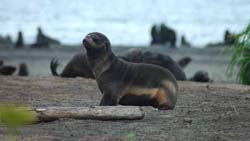
The reporter of the local radio pays us a visit for an interview. While
talking, she confirms the decreasing of fur seals population these last
years. Researches to find out why just start : Global warming, over
fishing ? No scientist are present on the island to ask them about their
investigation. The rest of the crew enjoy the last moment in this
beautiful and peaceful place.
At one, everybody is onboard as planned
for leaving. We start with light winds. Soon St Paul Island disappears
in the mist. Couple of hours later, St Georges, the second Island of
Pribilov archipelago is in sight. Off shore, “Dalnoi Point”, we check
carefully the compass because magnetic anomalies are indicated on the
map. When the Island is cleared, we can put more East in our South and
go strait toward Unalaska in the Aleoutian.
|
|
19 september , 2008 (Onboard
time = UTC - 8)
St Paul, Pribilov
22h30 local time
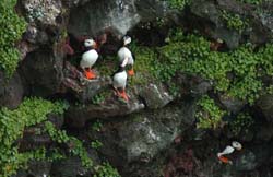
As usually, we have a warm welcome from the local population. In the
afternoon, the crew goes to discover the Island guided by Catherine who
knows every spot here. Fur seals are gathering by hundreds on the beach
while Puffin are occupying cliffs. The grass here is so green, it’s
amazing for us coming from the Far North with its harsh deserted flat
lands.
In the evening, we’re invited to join the community at school for
a dinner organized in view to help young people in California. A basket
ball match is going on while we’re here. The local team against the
Coast Guards. After this beautiful moment, we’re going back on board
under a thin rain.
|
|
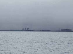
18 september , 2008 (Onboard
time = UTC - 8)
Bering Sea, Arrival St Paul, Pribilov
57°07’N – 170°17’W
23h55 local time
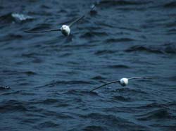
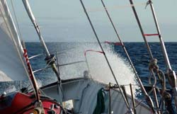
The wind is getting stronger, we’re sailing fast to our target. Our
predictions for arrival are getting shorter. We cross hundreds of birds,
petrel fulmar, storm petrel, couple of long tails Jaeger.
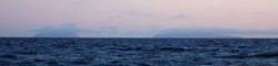
In the
afternoon, the Island is visible (picture). The plan for landing is to
clear the island by the west coast. We reach it at sunset, swell breaks
heavily on to the cliffs. When we pass “Southwest Point” and its
breakers, lights of the village are visible. The South coast is quite
calm and we can conceive to enter the small harbor of Saint Paul. The
entrance open to the west is shallow and could be dangerous by heavy
swell. It’s 23h30 when the jetty protect us from the waves. Two fishing
boats are unloading their catch, probably halibut.
Saint Paul Island is
the westernmost point of the expedition.
|
|
17 september , 2008 (Onboard
time = UTC - 8)
Bering Sea, 59°49’N – 169°39’W
23h20 local time
The wind is steady blowing from the North-West. We sail direct toward
Saint Paul Island. The Bering sea is peaceful. The team on deck watch
the horizon for wildlife. Birds are more and more numerous, couple of
whale blows are observed from a distance.
In the evening, before the
moon rises, the night is dark like ink. The team on watch finish a
manoeuvre in front when they hear a blow near the boat. The whale is
there couple of meters but soon the darkness cut this mysterious vision
off. When they come back in to the cockpit, a big smile on their face
witness the scene there were alone to watch.
|
|
16 september , 2008 (Onboard
time = UTC - 8)
Bering Sea, 62°20’N – 168°58’W
22h30 local time
We had a rolling night but it fulfilled our wishes. We set sails after
breakfast toward St Paul Island, Probilov. Next to the east coast, we
can see in the distance a fin which looks as a female killer whale one.
After couple of hours, the island looks like an archipelago. Only
mountains are visible, all flat land disappeared under the horizon.
During the day, we have a good deal of fog. The radar is watching and
confirms what we already know : there is no much traffic in here. Our
last vessel was in Queen Maud Gulf on August 22sd. The temperature is
raising up to 16°C. We do not have on board the average curve for the
season in this region but it looks very warm for mid September in the
middle of Bering Sea.
|
|
15 september , 2008 (Onboard
time = UTC - 8)
St Lawrence Island – Bering Sea
63°20’N – 169°05’W
23h35 local time
The wind is falling down, we’re sailing slowly. The temperature is 11°C,
for us, it’s almost tropical. We switch one heather off. The new wind
chart, confirms the calm period of 48 hours, we’ll definitely call at St
Lawrence Island waiting for the wind. At sunrise, the Island is in sight
but we have to wait couple more hours to cast anchor next to a beach in
the North East part of the coast.
The landscape is made of mountains
(200 up to 670 meters high) separated with flat plains. Slopes are
gentle and invite us for a trek on shore. Unfortunately, the swell is to
big to land with the dinghy. We spent our afternoon busy, every one in
his or her activities watching time to time this land we’ll not visit.
In the afternoon, a group of four men pay us a visit. They are coming
back from a camp where they search for fossilised walrus ivories. Their
village is still far away, they keep going and disappear soon to the
horizon.
|
|
14 september , 2008 (Onboard
time = UTC - 8)
Bering Sea, 64°05’N – 168°40’W
23h55 local time
At 2.30 AM we clear the Little Diomede on starboard side. We’re in the
middle of the strait and according with the Canadian Arctic Pilot, we
can validate our success through the North West Passage.
There is only nine years between my two crossing, but it’s a total
different world. The aim of this expedition was a field investigation to
collect witnesses about global warming but I was not expected at all to
be witness myself in a such short time of changes in these regions.
While we’re sailing our first miles in Bering Sea, We have a special
thought for our team on shore. It’s wonderful to know this sailing
expedition is not only an addition of nautical miles and a sportive
challenge. While we’re going on, the team on shore makes the message we
want to spread a reality.
Climate change is a fantastic opportunity to review our relation with
the environment. It’s impossible to find out which part belongs to the
nature and which part belongs to the Human being in this change. It’s
not a question to save the Earth but the Human being it self. The planet
does not care about our extinction. It is 12 750 kilometres in diameter.
To the scale of an orange, the atmosphere is only a cigarette paper and
the whole oceans are only three drops. Our vital space is not so big, we
can spoil it very quickly in one hand and in the other hand it offers us
every thing we dream about.
We have to rush to develop the energies of tomorrow. Fossils energy will
last longer and we could control it more efficiently. It can be a huge
economic development for our societies. Innovation and new technologies
for a better use of natural resources must be one of the main focuses
of industrialized countries who have the potential for massive
investment in researches. Why searching around our solar system, it’s so
much to do on Earth which is our unique and wonderful vessel.
Since the beginning of the afternoon, we have whales around. The weather
is calm. We’re talking about calling shortly at St Lawrence Island to
wait for the wind.
|
|
13 september , 2008 (Onboard
time = UTC - 8)
Chukchi Sea, approach of the Bering Strait
66°07’N – 168°33’W
22h30 local time
Winds are light. It is difficult to hold the sails, the swell makes them
flapping by moment but we keep going downwind, to the good direction and
still under a beautiful blue sky.
At 4.30 PM we pass the polar circle
which announces us the proximity of the strait. At this speed, we will
be obliged to wait for the second part of the night. In the evening, a
very good visibility gives us the occasion to see both Diomedes Islands,
Cape Dezhnev (804 meters) who marks the Siberian side of the strait and
Cape Prince of Wales (697 meters) who marks the American side of the
strait. The Diomedes are these two islands, only 4 kilometres away from
each other, just in the middle of Bering Strait. One is Russian (Big
Diomede 508 meters), the other one is American (Little Diomede 398
meters).
Here, between the Chukchi sea and the Bering sea, Russian are
on the West, American are on the East and every one can look each other
face to face
|
|
12 september , 2008 (Onboard
time = UTC - 8)
Chukchi Sea, 68°10’N – 167°13’W
22h45 local time
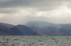
The weather is good, the sea calm, we sail quietly toward Cape Lisburne.
Discussions are more and more about Bering Strait. In the afternoon, we
are in front of Cape Lisburne. Its landscape is the end of the Brook’s
range. These hills are magnificent for us after all these weeks spent in
flat lands.
Just after, the sky clears up and we can enjoy a beautiful
sun. The evening marks our entrance in Kotzebue Bay by Point Hope. It’s
so nice to watch the sunset with its warm colours.
|
|
11 september , 2008 (Onboard
time = UTC - 8)
Chukchi Sea, 70°N – 164°20’W
23h50 local time
Our concentration is total. We ask the darkness, we torture our senses
to identify the ice. Presence of fluo plankton helps us a bit but our
best is to spot pieces of ice less than forty meters away. We’re lucky,
the weather is good and pack ice not dense. We keep in mind potential
technical problems we could have with a piece we did not see.
When the
light comes back, we welcome it with big enthusiasm. Some part are
finally quite dense in patches without being a real obstruction. A bow
whale pay us a visit. It’s 5 PM when we clear the last ice in our stern.
From now we should be in ice free water. |
|
10 september , 2008 (Onboard
time = UTC - 8)
Chukchi Sea, 71°02’N – 159°15’W
23h55 local time
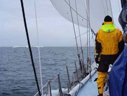
10 AM, we’re setting sail for the eighth leg of the expedition.
Everything is grey with scattered snow showers. We take the pass to the
off shore. Soon we clear the thin sand stripe of Point Barrow which is
the Northernmost point of Alaska. The depth sounder indicates six
meters. What a comfort to feel more water under the keel. The Dew line’s
buildings break the extreme monotony of the tundra while we’re heading
for Franklin Point.
The ice chart shows some in the vicinity of this
point, nothing dense but thick. At 5 PM, we can see the first pieces. We
keep going same direction. The light decreases, a heavy snow sticks to
the Plexiglas. We’re watching outside, well dressed, it’s cold. Before
midnight, we reduce the speed, it’s dark now. The bigger pieces of pack
ice are thick enough to be visible on the radar.
For visual watch, the
searchlight is useless with the snow. Night vision is finally the best,
we are careful to stay away from white light who destroy it. We put a
piece of plywood on top of the kitchen hatch because we come often here
to prepare warm drinks. The night promises us to be long.
|
|
|
| |
Copyright
Text & Pictures: Olivier Pitras (except other mentions)
|
|