|
Log Book
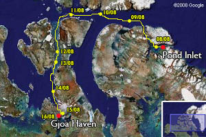
Leg 5 :
Pond Inlet - Gjoa Haven
(Nunavut - Canada) |
|
|
Leg 5
Pond Inlet - Gjoa Haven (Nunavut - Canada)
(August 8 - 16, 2008 )
|
|
August 16, 2008 (Onboard
time = UTC - 6)
Gjoa Haven, Nunavut, Canada.
23h30 local time
The leg of today is a short one. The Rasmussen Sound is calm, the wind from the north west light. We’re sailing quietly toward Gjoa Haven. We discuss a lot
about the ancient who were sailing in these regions without compass, engine, GPS, radar...
Approaching the village, we see one, two, three mast ! We’re entering in the tiny bay where Roald Amundsen and his companions spent two winters before
achieving the first navigation through the passage 105 years ago. We put our huge Norwegian flag up in memory of the Gjoa. Today, four yacht are at the
anchor ! What a change even since 1999 where “Ocean Search” was the only boat for the season. We invite the others crew to celebrate this unexpected
meeting and the end of the fifth leg of the expedition.
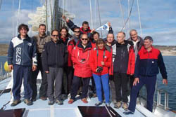
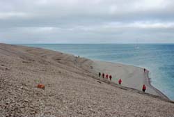
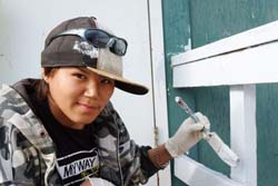
The crew from Pond Inlet to Gjoa Haven had two nationalities
From left to right :Gabriel Pitras (France),
Philippe Moreau (France),
Patrick Boidin (France),
Pierre Vanloot (France),
Philippe Rouillé (France),
Yannick Rouillé (France),
Olivier Pitras (France),
Luisa Nesbeda (Italie),
Daniel Desage (France),
Jean-Michel Bayada (France),
Dominique Dufayard (France),
Fabio Smundin (Italie)
Background on top :
Laurent Ceresoli (France)
|
|
August 15, 2008 (Onboard
time = UTC - 4)
Rae Strait,
68°51'N - 095°09'W
23h15 local time
The fog is with us again. The pack ice is too flat to give a good echo
on to the radar. Only a visual watch permitts us to find the route. When
we cross a big floe, we go systematically to the
coast. The poor visibility give sometimes the illusion that the route is
closed in front of a big floe. We know it's wrong and soon we can find
again ice free waters to keep going. We're
approaching the James Ross Strait when we have a call to the radio. It's
another yacht coming from Pacific. She is from Spain. We're only half
mille away but only a spot on the radar confirms
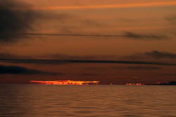
her presence in the zone. The visibility opens for two hours. We can
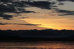
watch the sunset and the sunrise a short while after. The refraction is
important. Clouds are glowing.
At 7 AM, we 're
entering the James Ross Strait. The current is with us. It's no ice
anymore. Soon we can sail to the South toward the Rae Strait. We decide
to make a call for the night 25 milles before Gjoa
Haven, just South of Matheson Bay on King William Island. We can
celebrate this moment because we know now that we have no risk of
obstruction now on the Canadian archipelago.
|
|
August 14, 2008 (Onboard
time = UTC - 4)
Larsen Sound,
70°25'N - 096°38'W
23h55 local time
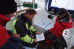
We get the new ice chart at 2h30. Conditions are far better and the wind
had decreased as planned. It's time to set sail. We point our bow
southward to the Franklin Strait and the Tasmania Islands. Nights are
more and more dark while we're sailing south. We have light enough to
navigate but we do need the artificial one for the inside. At 7h00 we
meet our first ice in stripes. Behind it's clear. Couple of floes are
drifting around but nothing to slow us down. The fog comes when we're
entering the Shortland Channel between Tasmania Islands and Boothia
peninsula. It's uncharted, the radar is on.
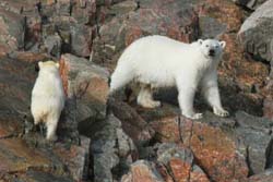
For a while the visibility
clears up and we can see two polar bears on shore, a female and her cub.
What a beautifull present. We keep going towards the channel and we see
another one, and another one a while later. This place is full of polar
bears. When we arrive at the south of the archipelago we saw 5 of them.
What a surprise. We push further south following the Boothia peninsula.
There is some big floes around but nothing bad. Next to the coast the
way is clear of ice. If we have the same ice conditions as we had since
Willis bay, we should reach the James Ross strait with no problem.
|
|
August 13, 2008 (Onboard
time = UTC - 4)
South Peel Sound,
71°57'N - 096°31'W
23h00 local time
The wind stays strong, we sail fast. This north-west push the ice from
the Mc Clintock to the Larsen Sound and increase the density of the
pack. In such conditions, it could be dangerous to
cross the obstruction. We decide to make a call at Willis Bay on the
south-east coast of Prince of Wales Island, before the limit of ice.
It's 5 AM when we cast anchor at the entrance of the bay.
After couple of hours of sleep, we go on shore. The landscape is
essentially mineral but we find a numerous species of arctic plants. It
makes the place warmer than it appeared from a distance
cold, without life. We find tracks of lemmings and reindeers. We take
samples of water and sediments before to return on board. From our
higher point of view, we can see in the south the first
big floes.
The ice in the Larsen sound is a thick first year ice in big
floes (500 meters to 2 kms). Pushed by the wind, the ice drift to the
James Ross strait in one hand and get grounded on the
west coast of Boothia peninsula in another hand. We have no other choice
than to wait for better conditions. |
|
August 12, 2008 (Onboard
time = UTC - 4)
Peel Sound,
72°31'N - 096°07'W
23h50 local time
We're entering the Peel Sound which lies between Prince of Wales and
Somerset Islands. A north westerly wind starts to blow. It's the end of
our tacking business. The sky is still cloudy but the visibility is
open. Patches of fog are very scattered now. We can see the first one
hundred meters in altitude of both islands. The landscape is very
desolated. In the evenning, the sun tries to give more colours with no
success and disappears after one minute.
We meet a group of belugas. We
sail fast (9 knots) southward to the Franklin strait where we have an
appointment with the pack ice. This wind from the North West does not
help and bring a lot of ice from the Mc Clintock channel to the Larsen
Sound. |
|
August 11, 2008 (Onboard
time = UTC - 4)
Barrow strait,
74°12'N - 094°W
23h55 local time
We keep tacking with a light wind, our speed is slow. It is raining. At
noon, we're entering the Barrow Strait following the north coast of
Somerset Island. The current is contrary, we're sailing
downwind now, our speed is even less. The north coast of Somerset Island
is rough and monotonous. Their is no snow, no glacier. While sailing in
front of Cunningham Bay, we remark that the
anchorage could be a good one for wintering.
We did not see any ice
since this morning. Soon, we'll sail south in the Peel Sound.
|
|
August 10, 2008 (Onboard
time = UTC - 4)
Lancaster Sound,
74°17'N - 088°37'W
22h30 local time
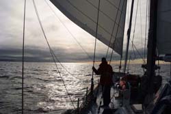
While we're sailing further west in the Lancaster, the wind comes. The
sky stays gray. At 6 AM, we're approaching a patch of pack ice who
drifts up from the Prince Regent Inlet. We dont go
inside because the route is ice free further north, we just leave it on
port side. During to hours, we keep going along side, our horizon in the
south is white. Our tacking business drive us in the midlle of the
afternoon on the north part of the sound.
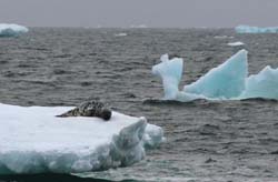
Suddently, the visibility
clears up and we can see a glimpse of Devon Island in the mist. We cross
a seal taking a nap on a big floe. We disturb him a little bit but after
a while he decides we do not represent a danger for him and he keeps
lying on the floe. Manoeuvering without gloves becomes difficult.
Pierre, ous scientist who takes Sea water samples often, tell us the sea
is 0,3°C and the air is 2,4°C.
|
|
August 9, 2008 (Onboard
time = UTC - 4)
Lancaster Sound,
73°51'N - 083°52'W
23h50 local time
We're crossing the Eclipse Sound towards the south west point of Byllot
Island. Everything is calm, the light is beautifull. Sea birds beat the
tempo in this motionless decor. From a distance we observe a group of
six
Narwhals. Early in the morning we're sailing in the Navy Board inlet who
drives us to the Lancaster Sound. Glaciers are numerous but few of them
are reaching the fjord. Icebergs are drifting
around, we enjoy them, there are our last icebergs, further west there
is none, only pack ice.
Seals are more and more visible around while
we're approaching the Lancaster Sound. We reach it in the end of the
afternoon. We do not have compass anymore, to close from the magnetic
pole, it does not work. In the evenning, we get a poor visibility with
rain, it makes the steering very difficult in this gray universe where
sea and sky are exactly the same. |
|
August 8, 2008 (Onboard
time = UTC - 4)
72°42'N - 079°03'W
23h55 local time
Today the village is busy. A lot of people get ready for their week-end
camping place, the others are working outside, maintaining buildings
before the end of the short summer. From our side we finish the last
details of preparation while waiting for the last two crewmembers. Pond
Inlet is a very charming place with beautifull people. The trip is going
on but people we met here make our departure frustrating. It was too
short.
7 PM, everybody is onboard, we start the fifth leg of the
expedition with calm weather. |
|
|
| |
Copyright
Text & Pictures: Olivier Pitras (except other mentions)
|
|